Vinson Creek Watershed
Summary
Characteristics:
- Eleventh largest watershed in West Vancouver
- Bordered by Lawson Creek watershed to the west and Brothers Creek and Swy-Wee Creek watershed to the east in West Vancouver, BC
- Originates on the side of Hollyburn Ridge
- Discharges into Burrard Inlet at the bottom of 13th Street
- Two branches; west branch originates just above British Properties and flows past Chartwell Elementary and the east side of West Vancouver Secondary, east branch originates near Upper Levels Highway and flows through Ridgeview Elementary school grounds and Chatwin Park. The confluence of the two branches is near Esquimalt Avenue near Hollyburn Elementary School
- Three diversions in main channel to Brothers Creek
- At Millstream Road, diverting all watershed above 366 m (1200 ft) to Brothers Creek at Eyremount, (1968)
- At Chartwell Drive, directing runoff above 275 m (900 ft) to West Brothers Creek (1972)
- At Cammeray Road, diverting all flow above 230 m (750 ft) to West Brothers Creek (1967)
- Ninety percent of the watershed is below 366 m, fully developed
- Impervious area high
History:
- Named for V. V. Vinson, reeve of West Vancouver in 1920
- Land at the mouth of the creek pre-empted in 1875 by J. C. Hughes, accountant at Moodyville
- Iron pipe installed in December 1913 from 13th and north of Esquimalt Avenue to a tap at Hollyburn School
- Several occurances of flooding and washouts caused by blocked culverts in the 1960’s and 1970’s
Watershed Use:
- Residential: watershed almost entirely urbanized, developed to 366 m
- Park: Chatwin Park, Ambleside Park
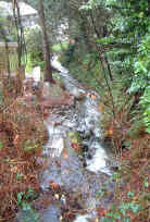
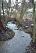
- Fish: cutthroat
- Wildlife: mammals and birds utilize the remaining riparian area and parks
- Train and automobile transportation, Trans Canada Trail, hydro lines
Concerns:
- Classified as Endangered by Fisheries and Oceans Canada due to impermeable area greater than 10% and urban development significantly affecting stream bed
- Morphology:
- Three diversions to Brothers Creek and 9 culverts (most classed as Steep) upstream of Upper Levels Highway
- Long culvert under Upper Levels highway
- At least twelve culverts downstream of the highway totalling about 1000 metres
- Channelization of creek and loss of tributaries through urban area
- Mouth of creek culverted, 110 metres long
- Thought to have little fish habitat left by 1977
- Water Quality:
- altered through proximity to urban development and storm drain discharge
- potential for sewer line breakages
Key Interest Groups:
- District of West Vancouver, District Parks Department
- Federal: Department of Fisheries and Oceans
- Provincial: Ministry of Transportation and Highways; Ministry of Water, Land and Air Protection
- West Vancouver Streamkeepers
- BC Rail, BC Hydro
- Mountain biking clubs
- Ambleside and Dundarave Ratepayers Association
Recommendations for Further Actions:
- Considered to be low priority for enhancement by 1977 due to severe degredation and poor water quality
Available Sources of Information:
Web Sites:
Reports:
- Lower Fraser Valley Stream Review, Vol. 1. Fisheries and Oceans Canada. Fraser River Action Plan, 1999
- Wild Threatened, Endangered and lost Streams of the Lower Fraser Valley, Summary Report. . Fisheries and Oceans Canada. Fraser River Action Plan, 1997
- Creeks in West Vancouver. Hugh Johnston?, 1990
- West Vancouver Drainage. Dayton and Knight, 1973
- Task Force Inquiry into Drainage Policies and Problems. District of West Vancouver, 1977
- History of West Vancouver. (A collection of newspaper clippings and miscellanea about the history of West Vancouver, in Memorial Library)
Prepared by Elizabeth Hardy, March 2003