Vinson Creek Watershed
Summary
Characteristics
- Eleventh largest watershed in West Vancouver
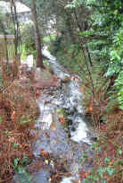
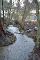
- Originates on the south side of Hollyburn Ridge in two branches. The west branch originates just above British Properties and flows past Chartwell Elementary and the east side of West Vancouver Secondary. The east branch originates near Upper Levels Highway and flows through Ridgeview Elementary school grounds and Chatwin Park. The confluence of the two branches is near Esquimalt Avenue near Hollyburn Elementary School. The creek is culverted from Gordon Avenue until it enters Burrard Inlet at the foot of 13th Street.
Watershed Use
- Residential: watershed almost entirely urbanized, developed to El. 1200 (366 m)
- Park: Chatwin Park, Ambleside Park
- Fish: cutthroat
- Wildlife: mammals and birds utilize the remaining riparian area and parks
- Train and automobile transportation, Trans Canada Trail, hydro lines
Concerns
- Classified as Endangered by Fisheries and Oceans Canada due to impermeable area greater than 10% and urban development significantly affecting stream bed
- The creek has three diversions to Brothers Creek in the upper watershed and is extensively culverted along it's length. The creek flows to Burrard Inlet through a 110 metre culvert. Channelization and other modifications of the open creek resulted in little fish habitat remaining by 1977
- Water quality has been altered through proximity to urban development and storm drain discharge and the potential for sewer line breakages
Watershed Projects
Prepared by Elizabeth Hardy, March 2003