McDonald Creek Watershed
Summary
Characteristics
- Fourth largest watershed in West Vancouver
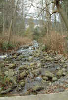
- Originates on the south side Hollyburn Ridge in Cypress Provincial Park. Flows through forests until reaching the urban environment at Whitby Estates. Three branches come together before being culverted under the Upper Levels highway. Creek flows under Queens Avenue and Mathers Avenue, through Hay Park, past Inglewood, Fulton and Esquimalt Avenues and through Memorial Park. The lower section of the creek is flumed from Marine Drive until it discharges into Burrard Inlet near 19th Street and the West Vancouver Seawall
Watershed Use
- Residential
- Commercial along Marine Drive
- Recreational: parks, hiking trails, cross-country ski trails, mountain biking
- Fish: cutthroat trout, coho and sculpin to Fulton Avenue
- Wildlife: tailed frog in upper watershed and urban area above highway, mammals, birds and amphibians in forested areas and urban riparian zones
- Water licence for 9.375 cubic feet per second for Residential Power purposes
Concerns
- Classified as endangered by Fisheries and Oceans Canada
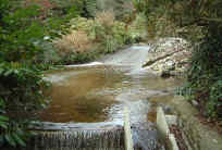
- Obstructions and barriers to fish migration include Fulton Avenue culvert, a concrete dam between Fulton and Inglewood Avenues, Kings Avenue footbridge, Mathers Avenue culvert, the natural cascades upstream of Mathers Avenue, Queens Avenue culvert, Upper Levels highway culvert, Westhill Way culvert
- Urbanization impacts including channelization of creek and loss of tributaries, lack of large woody debris, lack of suitable spawning substrate
- Water quality altered through proximity to urban development and storm drain discharge and the potential for sewer lines breakages
- Redevelopment and current development in upper watershed and associated problems, including an increase in imperviousness, construction of storm drain network resulting in altered water quality and quantity, degradation of riparian area, removal of portion of watershed by draining directly into diversion
Watershed Projects
- Spawner survey, 2002
- Unfed coho fry release, 2000, 2001, 2002
- Fish ladder installed in flume and box culverts from mouth to Memorial Park, 2001
- Tailed frog studies by school children, 1998
Prepared by Elizabeth Hardy, March 2003