Marr Creek Watershed
Summary
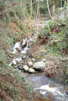
Characteristics
- Eighth largest watershed in West Vancouver
- Originates south of Hollyburn Ridge in Cypress Provincial Park as two branches
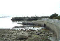
- Discharges into Burrard Inlet east of the Dundarave Pier
- First Lake at Hollyburn Lodge and Fourth Lake are in the headwaters
- Several small and ephemeral tributaries, several small lakes and wetlands in headwaters
Watershed Use
- Residential:
- Commercial: Dundarave Village shopping area
- Schools: Collingwood Elementary, Irwin Park Elementary
- Park: Dundarave Park, Cypress Provincial Park
- Recreational: Hollyburn cross-country ski area, Hollyburn cabin area, TransCanada Trail, Skyline Trail, Forks Trail, West Lake Road, Hollyburn Mountain Trail
- Fish: cutthroat trout from First Lake and downstream
- Wildlife: northwest salamander, tailed frog, long toed salamander, mammals, birds and amphibians inhabit the watershed
Concerns
- Obstructions and barriers to fish migration include culverting from mouth to Marine Drive, six road culverts, culverts under Upper Levels Highway and Cypress Bowl Road, weir at First Lake, several ski trail culverts
- Loss of spawning and rearing habitat due to channelization of creek, loss of tributaries and lack of riparian vegetation through urban area
- Water quality altered through proximity to urban development and storm drain discharge and the potential for sewer line breakages
- Current and future development in upper watershed and associated problems, including increase in imperviousness, loss of wetlands and tributaries, construction of storm drain network resulting in altered water quality and quantity, encroachment into riparian zones, tributary channelization, bank alteration and increased erosion into creek
Watershed Projects
- Unfed coho fry released in 2000, 2001 and 2002
Prepared by Elizabeth Hardy, March 2003