Godman Creek Watershed
Profile
Characteristics:
- Tenth largest watershed in West Vancouver
- Bordered by Cypress Creek watershed to the west and Turner Creek watershed to the east in West Vancouver, BC
- Originates on Hollyburn Ridge near Eagle Lake Road
- Discharges into Burrard Inlet west of Sandy Cove Park
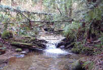
- Three branches, centre branch is the main channel, confluence below Upper Levels Highway at Westridge Park
- About 33% of watershed is above the 366 m limit of development, 46% is between the current upper limit of development and the Upper Levels highway, and 21% is between the highway and Marine Drive
History:
- The land at the mouth (District Lot 559) was pre-empted in 1886 by Murray Thain, the first Harbourmaster. The creek was named for Richard Godman, who applied for water rights on the creek in 1907. In 1918 James Nasmyth built a flume pond north of the railway on this creek. A vee flume from the 700 m elevation carried sawn lumber to a planermill and loading platform at this point. Water from Rodgers Creek supplied the flume, which was abandoned in 1923.
Watershed Use:
- Residential
- Park: Sandy Cove Park, Sharon Park, Westridge Park
- Recreation: hiking, mountain biking
- Fish: cutthroat trout, possibility of chum and coho spawning between mouth and Marine Drive
- Wildlife: diverse populations of mammal, bird and amphibian inhabit the watershed
- Train and automobile transportation, Eagle Lake Road, power lines
Concerns:
- Morphology:
- Obstruction to spawning salmon at Marine Drive culvert
- Culvert at Marine Drive, culvert under railway, 7 road and driveway culverts, footbridges, three culverts under Upper Levels Highway
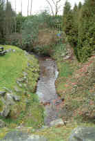
- channelization of creek and loss of tributaries through urban area
- Water Quality:
- altered through proximity to urban development and storm drain discharge
- possible sewer lines breakages
- Possible future development in upper watershed and associated problems, including:
- increase in imperviousness
- loss of wetlands and tributaries
- construction of storm drain network resulting in altered water quality and quantity
- encroachment into riparian zones
- tributary channelization, bank alteration
- increased erosion into creek
Key Interest Groups:
- Municipal: District of West Vancouver, District Parks Department
- Federal: Department of Fisheries and Oceans
- Provincial: Ministry of Transportation and Highways; Ministry of Water, Land and Air Protection
- West Vancouver Streamkeepers
- BC Rail, BC Hydro
- Ratepayers Association
- Mountain biking clubs
Watershed Projects:
- Unfed coho fry released 2000, 2001 and 2002
- Biophysical survey 1980 [FISS]
Recommendations for Further Actions:
Available Sources of Information:
Web Sites:
Reports:
- Lower Fraser Valley Stream Review, Vol. 1. Fisheries and Oceans Canada. Fraser River Action Plan, 1999
- Wild Threatened, Endangered and Lost Streams of the Lower Fraser Valley, Summary Report. Fisheries and Oceans Canada. Fraser River Action Plan, 1997
- Creeks in West Vancouver. Hugh Johnston?, 1990
- West Vancouver Drainage. Dayton and Knight, 1973
- Task Force Inquiry into Drainage Policies and Problems. District of West Vancouver, 1977
Prepared by Elizabeth Hardy, March 2003