Thames Creek Watershed
Summary
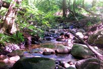
Characteristics
- Thames Creek is the main tributary of Hastings Creek
- Thames headwaters north of the urban development of Lynn Valley and flows south through residential area in Lynn Valley until it joins Hastings Creek at Ross Road
- Thames Creek is bordered by the Coleman Creek Watershed to the west and the Pierard Creek Watershed to the east
- 21% impervious surface in the Hastings Creek Watershed (GVRD, 1999)
- 54% of the Hastings Creek Watershed had forest cover (GVRD, 1999)
Watershed Use
- Fish: Cutthroat Trout
- Wildlife: Various species including raccoons, mink, river otters, black bears
- Vegetation: Coastal Western Hemlock, dry subzone.
- Residential: The area surrounding Thames is highly residential
- Parks: Upper reach parallels Baden-Powell Trail
- Schools
Concerns
- Stream classified as endangered due to impacts (FRAP)
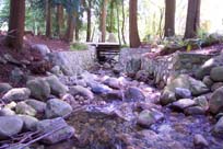
- Significant loss of riparian vegetation along more than 50% of the fish frequented length of the stream due to development and removal by landowners (FRAP)
- Urbanization in the watershed has significantly affected the stream basin (FRAP); 17 storm drains flow into Thames
- Channelization and/or armourization (riprapping) of over 50% of the fish frequented length of the stream (FRAP)
- The construction of culverts severely reduced coho populations
- Status: Endangered - due to riparian removal, urbanization, culverting and degraded water quality