Mosquito Creek Watershed
CONCERNS
- Hydrology: Risk of further loss of quantity and increased peak flows from increased development and densification.
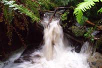
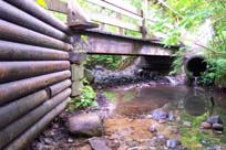
- Stream Channel: Has been significantly altered by flood control engineering works above the Trans Canada Highway, and below.
- Water Quality Has been compromised by stormwater discharged from residential, commercial and industrial developed areas, bank erosion from runoff and foot traffic.
- Wagg Creek and Lower Mission Creek have serious non-point source pollution and water quality problems.
and resort activities from the Grouse Mountain Ski Resort.
- Fish and Wildlife Habitat: Many attributes have been eliminated by development.
Lack of refugia, for fish and aquatic animals, is a major problem in the main stem.
Fish passage upstream is blocked by Queens culvert (Thain) and Jones culvert (Wagg).
- Estuary: Most of the estuary has been lost.
- Intensive Development: Development and proposed redevelopment in the watershed increases the risk of further water quality and quantity impact from storm water, spills, encroachment, loss of riparian area, unauthorized stream works, recreational/conservation trail use conflicts and bank/channel alterations.(ref-DFO-1998)
LAND USE
- Fish and Wildlife: Second growth forest throughout Upper watershed.
- Habitat linear in Mid and Lower watershed. Second growth forest along stream corridor, interrupted by Highway 1 and other bridges. Widest in and along ravines. A few small wetland areas. Loss of riparian due to trails all along stream bank. Outside of ravines, urban development (residential land use) dominant.
- Migratory routes are North-South along stream and East-West along lanes and residential properties between Mosquito Creek and adjacent creeks and watersheds.
- Human: Upper watershed is second growth forest. Lower elevations logged prior to 1915. Upper elevations logged 1950-1970, last in 1970.
- Recreational ski area (toll road to top of Grouse Mountain constructed 1926), trails.
- Mid and Lower watershed urban development began around 1910. Residential, Commercial, Industrial, Institutional, Recreational. Heavily urbanized. Encroachment into riparian areas.
- The mouth of the steam historically supported a large estuary which no longer exists.
- The foreshore between Fell and Bewicke was filled and extended 500m into the inlet for industrial use (1912-1915).
- The eastern part of the Mosquito Creek Estuary was filled in 1960.
- Water quality problems. High impervious (44% Wagg).
PROJECTS
- Water Quality Monitoring: Continuous monitoring for 1 year - Wagg Creek (CNV 1998)
Benthic Assessment - Mosquito Creek, Wagg Creek (GVRD 2000)
-
Fish Habitat:
- Wagg Creek - Slot Fish Ladder 1985 (CNV)
- Mosquito Creek - East Bank Back Channel 1996 (BC MoTH)
- Mosquito Creek - Fish Ladder 1996 (GVRD)
- Mosquito Creek - West Bank Back Channel 1998 (CNV)
- Mosquito Creek - Griffin Side Channel 1998 (DFO, DNV)
- Mosquito Creek - Fell Side Channel 1999 (DFO, CNV)
- Thain Creek - Daylight Thain Culvert 1999 (CNV)
- Thain Creek - Fish Baffles Westview Culvert 1999 (CNV)
- Upper Mission Creek - Fish Baffles Cartelier Culvert 2000 (DNV)
- Thain Creek - Fish Ladder 2003 (DNV)
- Thain Creek - Fish Baffles Queens Culvert 2003 (DNV)
-
Fish Management:
- Spawner Survey - 1995-2003 (MCSS) 1998 (DFO)
- Fish Sample - 1996-2002 (CNV), 1998 (MCSS), 2000 (DFO), 2003 (DFO)
- Fish Ladder Maintenance - 1996-2004 (MCSS)
-
Revegetation:
- Mosquito Creek - East Bank Slope Stabilization and Planting 1995 (CNV)
- Mosquito Creek Park - Trail Entry 2000 (CNV)
- Thain Creek - Slope Stabilization 2000 (DNV)
- Mosquito Creek Trail 2001 (CNV), 2002 (DNV)
- Mosquito Creek Lane - Bank Replanting 2003 (Evergreen Foundation)
- Wagg Creek - Bank Stabilization 2003 (CNV)
- Mahon Park - Invasive Removal and Replanting 2003 (CNV & Evergreen Foundation)
- Mapping:
- GIS - Streams, Streets, Schools, Parcels, Contour (DNV),
- Streets, Parcels, Buildings, Streams, Catchments, Contour (CNV)
- GPS - All streams 1997 (DNV)
- Orthophotos - All lands 1995 (CNV, DNV)
- Stream Features - measurements, photos - Mosquito Creek, Thain Creek 1997 (NSK/MCSS)
- Stream Erosion Points - photos - Mosquito, Wagg, Lower Mission, Mackay Creek 1998 (CNV)
- ESA - Identification and Mapping 1997 (CNV)
STAKEHOLDERS
- GOVERNMENT
- Federal: Canada Coast Guard, Environment Canada, Fisheries and Oceans Canada
- Provincial: Province of BC - MWLAP, MoT, MoSRM
- Municipal: City of North Vancouver, District of North Vancouve
- Other: Squamish Nation, Vancouver Port Authority
NON-GOVERNMENT
- Schools: School District 44 (10) Private (2)
- Residents Associations:
- Courthouse Area Residents' Association
- Delbrook Community Association
- Edgemont Community Association
- Lonsdale Citizens' Association
- Mosquito Creek Neighbourhood Association
- Queensdale Ratepayers Association
- Upper Delbrook Community Association
- Federation of North Vancouver Community Associations (FONVCA)
- Business Associations: Lower Lonsdale Business Association
- Interest Groups:
- North Shore Historical Society, North Shore Search and Rescue, RCMP Block Watch
- Environment - Mosquito Creek Stewardship Society, North Shore Fish and Game Club, North Shore Streamkeepers, Vancouver Natural History Society, Wild Bird Trust
- Recreation - North Vancouver Recreation Commission, North Vancouver Sport Council, Outdoor Recreation Council
KEY CONTACTS
REFERENCE
REPORTS
- Environmental Effects of Stormwater Discharges on Small Streams - Habitat and Benthic Assessment
- Greater Vancouver Regional District - Liquid Waste Management Plan
- April 2000
- Prepared by: EVS Environmental Consultants, North Vancouver, BC
- (9 watersheds included: Mossom, Coghlan, Mosquito, Yorkson, Stoney, Upper Serpentine, Wagg, Como, Still)
- Mosquito Creek Flood and Erosion Study - Final Report March 2000
- City of North Vancouver
- March 2000
- Prepared by: Kerr Wood Leidal Associates Ltd., North Vancouver, BC
- Lower Fraser River - Strategic Review
- DFO
- 1998-99
- (Contains errors)
- Wild, Threatened, Endangered and Lost Streams of the Lower Fraser Valley - Summary Report 1997
- Fisheries and Oceans Canada
- 1998
- Prepared by: Precision Identification Biological Consultants, Vancouver, BC
- Protection of Aquatic and Riparian Habitat by Local Governments - An Inventory of Measures Adopted in the Lower Fraser Valley, 1995
- Fisheries and Oceans Canada - Fraser River Action Plan
- 1995
- Prepared by: Quadra Planning Consultants, West Vancouver, BC
- Fish Habitat Inventory & Information Program
- Stream Summary Catalogue - Subdistrict #28A Vancouver
- Department of Fisheries and Oceans
- April 1989
- Report on Creek Systems and Storm Water Control - Summary Report
- District of North Vancouver
- 1982
- Prepared by: Kerr Wood Leidal Associates Ltd., North Vancouver, BC
MAPS
PRINT
- Parks of North Vancouver
- City of North Vancouver, District of North Vancouver
- 1998
- Access: Municipal Hall - District of North Vancouver, City Hall - City of North Vancouver
- Orthophotos - District of North Vancouver
- 1995
- Access: Municipal Hall, District of North Vancouver
- Historical Aerial Photographs
- Access: UBC Geography Department Library
- TRIM Map: 92G035
- Access: BC Ministry of Environment, Lands and Parks
- Mosquito Creek Watershed
- www.mosquitocreek.org/maps.shtml