McCartney Creek Watershed
Summary
Characteristics
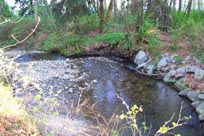
- Originates in a forested area of Seymour Heights. The creek has a steep incline and flows through a series of steps to the Maplewood Estuaries in Burrard Inlet.
- 4 tributaries including McCartney, Trillium, Woods, and Mountain Creeks.
- Status: Endangered; Trend: Declining (Precision, 1997); 15% impervious area in watershed
Watershed Use:
- Main freshwater input into Maplewood estuary which provides habitat for fish and birds
- Mouth and surrounding uplands make up the Maplewood Flats Wildlife Sanctuary
- Hemlock Creek and riparian corridor provide wildlife habitat and travel corridor
- Fish: Coho, chum, cutthroat trout
· CDNV waterline
- Residential
· Recreation: parks, trails, etc.
Concerns
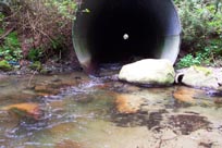
- Classified as endangered due to impacts such as riparian removal, urbanization, culverting, and degraded water quality (DFO, 1998).
- Decreasing escapement figures (DFO, 1998).
- Maplewood-Lynnmour area – high level of air pollution (GVRD ambient air monitoring).
- Significant water quality problems (FRAP):
- Urbanization in the watershed has significantly affected the stream basin (FRAP).
- Progressive sedimentation and plugging of trash racks at culvert inlets under flood flow conditions in tributary channels in upper reaches (Kerr Wood Leidal Associates, 1982).
- Debris flow or debris flood risk rated moderately high (Kerr Wood Leidal Associates, 1999)
- CDNV waterline exposed due to erosion or poor installation (Gartner, 1995).
Watershed Projects
- Capilano hatchery, SEP volunteers, and local schools have released fish
- Various public interest groups fought development on the Maplewood Flats.
- 99-00 – McCartney Community Association undertook 5 projects to enhance fish passage and reduce nutrient inputs.