Characteristics
- Hoskins originates north of Lynn Valley Road and is culverted between Peters Road and Platt Crescent. Hoskins flows south through a residential neighbourhood until it joins Hastings Creek in Hastings Creek Park?
- Hoskins Creek is a tributary of Hastings Creek
- Hoskins Creek is located between the Lynn Creek Watershed to the east and the Pierard Creek Watershed to the west
- 21% impervious surfaces in the Hastings Creek Watershed (GVRD, 1999)
- 54% of the Hastings Creek Watershed had forest cover (GVRD, 1999)
History
- Hastings Creek and its numerous tributaries made up the prime spawning area for most of the Lynn’s migratory runs of cutthroat, steelhead, coho and chinook. This watershed contained excellent spawning and rearing habitat for salmon and trout, and had strong coho runs.
- 1860’s - The first significant non-native settlement began as the Douglas-fir and Western white pine were cut for spars or sailing ship masts and exported to Britain for Royal Navy ships. Lynn Valley became known as spar forest as it provided spars 70 feet long and 13 feet in diameter
- 1875 – Logging for red cedar bolts became the main activity
- 1899 - First home in Lynn Valley built by J.M. Fromme in a clearing from the logging (Eikos Design Group, 1978) (Draycott, W. M., 1919)
- Early 1900’s – Accidental introduction of white pine blister rust (Cronartium ribicola) results in the loss of most of the Western white pine on the North Shore
- 1903 – Fromme subdivides his lot selling 60 blocks at $25 per acre
- 1904 – 1st school opens on May 20th
- Lynn Valley Population: 1909 = 200; 1919 = 1400; 1971 = 25,000
- Late 1940’s – Balsam woody aphid (Chermes piceae) is introduced impacting the Amabilis fir
Watershed Use
- Fish: Coho
- 11 cutthroat found above and below Draycott and Kilkenny Roads in 1993 Fish Trapping Survey (District of North Vancouver, 1993)
- Wildlife: Various species including raccoons, mink, river otters, black bears, Belted Kingfishers, Dippers, Great Blue Herons, Common Mergansers, Harlequin Ducks, and Swallows (Tera Environmental Consultants Ltd.)
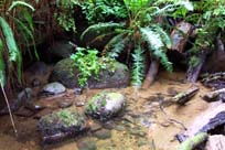
- Vegetation: Coastal Western Hemlock, dry subzone. Remaining native trees in watershed include western hemlock, douglas-fir, western red cedar, big leaf maple, and red alder up to about 120 years old
- Parks: Pierard Park; Draycott Park; Hastings Creek Park
- Schools: Westover Elementary; Ross Road Elementary
- Residential: the area surrounding Hoskins Creek is primarily residential
Concerns
- 18 storm drains flow into Hoskins. Construction of storm drain network results in flash flooding, erosion and polluted storm water being flushed directly into the creek
- High incidence of introduced plant species including Himalayan Blackberry and English Ivy
- 21% impervious area in watershed (GVRD, 1999)
- The culverts at Ross Road are a barrier to fish migration (NSSK, 2001)
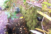
- Hoskins Creek is being used as a trash dump in Hastings Creek Park (below Haverhill Place) (NSSK, 2001)
- Loss of riparian zone north of Ross Road
Key Interest Groups/Government Bodies
- Municipal Gov’t: District of North Vancouver (DNV); District Parks Department; Lynn Canyon Ecology Centre
- Regional Gov’t: GVRD (regional parks, sewers and air quality); GVWD
- Provincial Gov’t: Ministry of Transportation and Highways; Ministry of Environment, Lands and Parks
- Federal Gov’t: Department of Fisheries and Oceans; Environment Canada; Transport Canada
- Local NGO’s: North Shore Streamkeepers; North Shore Fish and Game Club; Pacific Streamkeepers Federation; Lynn Valley Community Association
- BC Hydro
- School District 44
- North (Shore/Vancouver) Historical Society
Watershed Projects and Good News
- The lower reach of Hoskins Creek is protected in a park
Recommendations and Suggested Actions
- Development options should consider the presence of a creek an enviable feature rather than an obstacle (Brooks Planning Group Ltd., 1976)
- Protect all stream corridors as open landscape features on both private and public property (Brooks Planning Group Ltd., 1976)
Bibliography and Available Sources of Information
BC Ministry of Environment, Lands and Parks. TRIM/UTM Maps.
District of North Vancouver Fish Trapping Summary. (1993). Unpubl.
District of North Vancouver. Storm Drain Maps. Map Pages: J-11, J-10, J-9.
GVRD. (August 1999). Assessment of Current and Future GVS&DD Area Watershed and Catchment Conditions. Prepared for: Liquid Waste Management Plan. Stormwater Management Technical Advisory Task Group.
North Shore Streamkeepers. (Spring 2001). Preliminary Watershed Assessments of 12 North Shore Creeks. Unpublished.
Steward, Barry. "Lynn Valley’s Creeks and Fish Habitats". (1975). North Vancouver: Lynn Canyon Ecology Centre. (North Shore Archives).
Tera Environmental Consultants Ltd. Seymour-Lynn Vegetation and Wildlife Species List