Hastings Creek Watershed
Summary
Characteristics
- Hastings Creek is one of the six tributaries of Lynn Creek.
- Originates on the east slope of Grouse Mountain. Thames Creek is the main tributary.
- Status: Endangered - 21% impervious area in watershed (GVRD, 1999).
Watershed Use
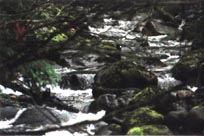
- Vegetation / Fish / Wildlife
- Parks: Hunter, Princess and Hastings Creek Parks: trails, dog-walking
- 3 current watershed licenses
- Residential
· 4 Schools
- Commercial
· Power line (Princess Park)
Concerns
- Water quality – Significant problems caused by urban development (FRAP).
- Loss of vegetation, and bank and slope stability leading to erosion and flooding.
- Road construction in the 1950’s created impassable culverts.
- Hastings Creek’s tributaries have been heavily culverted.
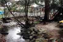
- Houses are located within creek floodplain.
Watershed Projects
- 1979 - Squaretailers Rod and Reel Club installed a fish ladder near the mouth.
- 1980 – DFO released steelhead
- 80/83 – Incubation box for coho at Lynn Valley Road.
- 91/92 - School District released coho at Roblin Place, Kirkstone Road and Hastings Creek Park.
- 1993 – North Shore Streamkeepers began work on Hastings. Installed fish ladder that allowed for the return of salmon into the mid-watershed. Other activities have included: stream bank clean-ups, storm drain marking, spawner surveys, smolt trapping, mapping, planting stream banks, and Donavon Pond restoration