Profile

Dyer Creek Watershed

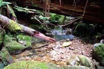
Total Drainage Area: km2
Length: 1 km
Orientation: Northeast to southwest
Elevation Range: 250 to 480 m
Average Channel width: 3 m

Characteristics

History

Watershed Use

Concerns

Key Interest Groups/Government Bodies

Bibliography and Available Sources of Information


Note
: Very little information exists on Dyer Creek. Most of the following references provide only indirect information on Dyer Creek.
BC Ministry of Environment, Lands and Parks. TRIM/UTM Maps.
Bouton, Cherry. (2000). North Shore History. www.cherrybouton.com/nshistory.html
Clark, B. (1985). Hastings Creek Habitat Evaluation. MoE: Fish and Wildlife Branch. Surrey, B.C.
District of North Vancouver Fish Trapping Summary. (1993). Unpubl.
District of North Vancouver. (2001). GIS Database.
District of North Vancouver. Storm Drain Maps. Map Pages: H-13, H-12, G-12
District of North Vancouver Website. (2001). Hastings Creek Salmon Restoration Update. www.district.north-van.bc.ca/admin2/depart/enviro/hastings%5Fcreek% 5Fupdate.html
District of North Vancouver. Lynn Valley Official Community Plan.
Draycott, W. M. (1919). ‘A History of Lynn Valley’.
Draycot, Walter. (1912). "Lynn Valley: From the Wilds of Nature to Civilization". North Vancouver.
Draycot, Walter. (February 2000). Early Days in Lynn Valley. North Vancouver, BC: Contact Printing and Mailing Ltd.
Gabby. "Logging History of the North Shore". (1994). North Vancouver: Lynn Canyon Ecology Centre Library.
GVRD. (August 1999). Assessment of Current and Future GVS&DD Area Watershed and Catchment Conditions. Prepared for: Liquid Waste Management Plan. Stormwater Management Technical Advisory Task Group.
The Lynn-Seymour Rivers and the Hastings Stream: Geologic History of Their Origin.
Steward, Barry. "Lynn Valley’s Creeks and Fish Habitats". (1975). North Vancouver: Lynn Canyon Ecology Centre. (North Shore Archives).
Tera Environmental Consultants Ltd. Seymour-Lynn Vegetation and Wildlife Species List.