Blueridge Creek Watershed
Summary
Characteristics
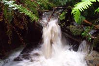
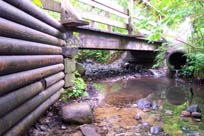
- Blueridge Creek starts north of Hyannis Drive and Berkley Avenue and flows south through Blueridge Park and the Blueridge residential area across Mount Seymour Parkway, and through a forested area until it joins McCartney Creek
- bordered by Seymour River Watershed to the west & McCartney Creek Watershed to the east
- 55% impervious surface in the McCartney Creek Watershed (GVRD, 1999)
- 55% of the riparian corridor has forest cover (GVRD, 1999)
Watershed Use
- Fish: Coho Salmon and Cutthroat Trout
- Wildlife: the riparian corridor besides providing habitat for various species, serves as a travel corridor. Likely species include: shrews, moles, weasels, bobcat, lynx, deer, fox, raccoon, otter, hares, coyote and bear, but no wildlife studies have been conducted
- Vegetation: Coastal Western Hemlock, dry subzone.
- Parks: Trillium Park, Blueridge Park
- Residential: the area around the upper reaches of Blueridge is primarily residential
- Schools: Seymour heights Elementary, Blueridge Elementary
- Commercial: Gas station (Chevron)
- District of North Vancouver: Ron Andrews Community centre and Blueridge Ice Rink
Concerns
- Watershed Health defined as poor (GVRD, 1999)
- 55% impervious surface in the McCartney Creek Watershed (GVRD, 1999)
- 29 storm drains flow into Blueridge Creek
- Maplewood-Lynnmour area – high level of air pollution (GVRD ambient air monitoring).