Characteristics:
- Second largest watershed in West Vancouver
- Discharges into Burrard Inlet at Fisherman’s Cove
- Originates on Black Mountain plateau
- Bordered by Larson Creek watershed to the west and Eagle Creek and Cypress Creek watersheds to the east in West Vancouver, BC
- Main tributaries and lakes: Dick Creek and Eagle Lake, Whyte Creek and Whyte Lake
- Several other small and ephemeral tributaries, several small lakes in headwaters on Black Mountain plateau
History:
- Nelson Creek named for August Nelson, a framer at Hastings Mill, who pre-empted District Lot 722 in 1886
- Whyte Lake and Whyte Creek are named after Colonel Albert Whyte, a principal figure in the West Shore and Northern Land Company, who laid out the building lots and streets from Horseshoe Bay to Whytecliffe
- Commercial logging operation started on Black Mountain in 1899, to cut the trees that had escaped a forest fire that spread from Hollyburn to Eagle Harbour in 1884. A flume was built from the head of Whyte Lake to carry logs down to Horseshoe Bay, followed the property line between District Lot 1495 and District Lot 1494
- Small siphon was installed in 1922 at Whyte Lake for water supply.
- Nelson Creek used as water supply for Horseshoe Bay and Whytecliff from 1923 until late 1980’s, intake at 143 m elevation, 20 cm intake pipe, pressure regulator at 76 m elevation. Intake is now used for Nelson Creek fish hatchery
- Eagle Lake developed as water supply using a small timber dam at the outlet, expanded to a major water supply and storage source between 1973 and 1977
- Estuary dredged in 1967 for development of Thunderbird Marina
Watershed Use:
- Residential: approximately 90 houses in the watershed
- Nelson Creek hatchery is located about 300 m upstream of Cranley Drive, raises chum and coho for West Vancouver creeks
- Water supply: water is diverted to Eagle Lake from mainstem and gathered from Dick Creek tributary for use as West Vancouver municipal water supply
- Park: Nelson Canyon Park set aside for municipal water supply
- Fish: coho to Cranley Drive impasse, chum to Marine Drive, cutthroat throughout, steelhead to Marine Drive
- Wildlife: diverse populations of mammal, bird and amphibian inhabit the watershed (ie. black bear, otter, great blue heron, kingfisher, American Dipper, Tailed Frog, Ensatina, Western Red Backed Salamander)
- Marina, train and automobile transportation, Trans Canada Trail, hydro lines
Concerns:
- Classified as endangered by Fisheries and Oceans Canada because of extensive modification by development (ie. dammed and dredged) and estuary lost
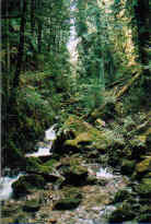
- Morphology:
- dredging for marina has resulted in elimination of lower 75 metres of the creek and loss of estuary and limited access at mouth for spawning fish (above 14 ft tide)
- culverting at Thunderbird Marina and under Telegraph Trail, Marine Drive and Cranley Drive has resulted in barriers for fish migration
- channelization of creek and loss of tributaries through urban area
- Water diverted from mainstem into Eagle Lake and gathered from Dick Creek tributary resulting in potential for reduced base flows and elimination of high fall water needed for spawning salmon
- Water quality:
- altered through proximity to urban development and storm drain discharge
- potential sewer lines breakages
- potential for contamination from Thunderbird Marina from paint, sewage and fuel
- Possible future development in upper watershed and associated problems, including:
- increase in imperviousness
- loss of wetlands and tributaries
- construction of storm drain network resulting in altered water quality and quantity
- encroachment into riparian zones
- tributary channelization, bank alteration
- increased erosion into creek
Key Interest Groups:
- West Vancouver Streamkeepers
- Federal: Department of Fisheries and Oceans
- Provincial: Ministry of Transportation and Highways; Ministry of Environment Lands and Parks
- District of West Vancouver, District Parks Department
- Thunderbird Marina
- Ratepayers Association
- BC Rail
Watershed Projects:
- Proposed fish ladder at creek mouth.
- Digitized map of urban watershed including storm drain network, SHIM website, 2001
- Hatchery built above the highway in 1991. Releases up to 100,000 chum and 60,000 coho per year to West Vancouver creeks
- Cement curb baffles installed in open box culvert at Marine Drive to improve fish access, Department of Fisheries and Oceans, 1999
- Water quality samples taken, North Shore Streamkeepers, 1999
- Cement curb baffles installed in the culvert at the mouth of Nelson Creek on Thunderbird Marina property, 1997
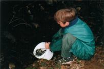
- Spawner surveys, West Vancouver Streamkeepers, 1997 onwards
- Stream survey, West Vancouver Streamkeepers, 1997
- Chum and coho incubation box at Cranley Drive between 1981 and 1986 (67500 coho and 75000 chum planted)
- Series of drops and pools created with large boulders in the lower 100 m section of the creek, 1972?
Recommendations:
- Maintain reliable water supply in the creek during the summer and early autumn
- Establish enforceable erosion control bylaws, to address the problems caused by siltation during house construction and renovation
- Increase public awareness and appreciation of the Nelson Creek watershed
- Complete habitat assessment of Nelson Creek
- Encourage the planting of native vegetation along the creek banks
- Study groundwater source at Marine Drive
Available Sources of Information:
Maps: TRIM/UTM 92G034
Web Sites:
- http://www.pskf.ca The Pacific Streamkeepers Federation
- www.bcfisheries.gov.bc.ca/fishinv/fiss.html Fisheries Information Summary System (FISS)
- www.bcfisheries.gov.bc.ca/fishinv/index.html includes FISS, Survey Data, Base Maps, Methods
- http://www-heb.pac.dfo-mpo.gc.ca/English/maps.htm includes Fish Wizard, Fisheries Project Registry, SHIM Data with Orthophotos, Wild Threatened, Endangered and Lost Streams of the Lower Fraser Valley
- www.shim.bc.ca Sensitive Habitat Information and Mapping
Reports:
- District of West Vancouver Drainage Survey. Dayton and Knight Ltd., 1973
- Water Supply Investigations, Report on Eagle Lake. D. W. Hodsdon, 1926
- Creeks in West Vancouver. Hugh Johnston?, 1990
- The Modernization of Horseshoe Bay, West Vancouver, B.C. Andre Ortmayr, 1984?
- West Vancouver Water Supply. H. B. Muckleston, 1930
- A Place of Excellence: A Chronicle of West Vancouver 1912-1987. Bruce Ramsey, 1986
- West Vancouver Sewerage Survey, Howe Sound to West Bay. Dayton and Knight Ltd., 1967
- Lower Fraser Valley Stream Review, Vol. 1. Fisheries and Oceans Canada. Fraser River Action Plan, 1999
- Wild Threatened, Endangered and lost Streams of the Lower Fraser Valley, Summary Report. . Fisheries and Oceans Canada. Fraser River Action Plan, 1997
- North Shore Streams- Nutrient Impacts. North Shore Streamkeepers, 1999
- DFO/MOEP Fish Habitat Inventory and Information Program, Stream Information Summary. 1989
- West Vancouver Streams: Nelson Creek. Munro Environmental Consulting, 1998