Chineside Watershed
Profile
Characteristics
- The 7th largest watershed in Port Moody (out of 16), this watershed is also known at the Kyle Street Catchment.
- Bordered to the west by the South Schoolhouse Creek watershed, to the east by the Slaughterhouse Creek watershed, to the south by the District of Coquitlam, and to the north by the Port Moody Arm of Burrard Inlet.
- Average annual watershed precipitation is 1750 mm (GVRD 1999).
- Average annual watershed flow is unknown, but the catchment drains 1007 mm of stormwater runoff annually.
- In 1996 42.3% of the watershed was developed and impervious to water (GVS&DD 1999).
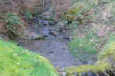
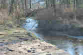
- The Chineside watershed consists of 7 creeks which originate as sidehill runoff on the north facing slopes of Chineside Park. These creeks are, from west to east, Ottley Creek, Axford Creek, Kyle Creek, Hachley Creek, West Sundial Creek, East Sundial Creek, and Goulet Creek. Each of these streams flow north through steep ravines until they are culverted as they reach the northern edge of Chineside Park. Ottley Creek leaves Chineside Park and enters its culvert on the south side of Henry Street between Douglas and Elgin Streets. Axford Creek enters its culvert at the southern end of Elgin Street. Kyle Creek enters its culvert at the southern end of Kyle Street at Kyle Park. Hachley Creek enters its culvert at the southern end of Grant Street. West and east Sundial Creeks join 200 meters south of the end of Moody Street, and this stream enters its culvert at the southern end of Moody Street. Goulet Creek enters its culvert at the southern end of Hugh Street. All of these culverts flow beneath Moody Centre to a single collector duct which empties into a short channel on the north side of Murray Street at the entrance gate to Pacific Coast Terminals. This channel flows north 50 meters until it enters the the Port Moody Arm of Burrard Inlet.
History
- The Canadian Pacific (transcontinental) Railroad, which crosses the northern end of this watershed, was completed in 1886. (City of Port Moody website).
- During the 1950s industrial and residential development covered the lower section of this watershed as Port Moody became "suburbanized" (City of Port Moody website). The steep ravines of what is now Chineside Park are naturally unstable, which spared them from development (Schaefer et al. 1992).
- Industrial activities have polluted the marine environment of Port Moody Arm into which the Chineside creeks flow, leading Environment Canada to identify this area as an "environmental hotspot" in 1992 (Dunster and AXYS 1999). These pollutants include the metals cadmium, chromium, copper, lead, and zinc (originating from metal coating, plastic stabilizers, paint pigments, and, to a lesser extent, pesticides and sewage), as well as organic compounds like oil and grease hydrocarbons and polycylic aromatic hydrocarbons (originating from petroleum facilities). Polychlorinated biphenyls (PCBs, used to produce plastics, inks, paints and pesticides but banned since the mid-1970s) persist in low concentrations throughout Port Moody Arm. In 1987, all of these pollutants occured in the highest concentrations near the Ioco refinery, decreasing in concentration towards Indian Arm and the Port Moody tidal flats (Environment Canada 1989).
Watershed Use
- Residential: predominantly single-family residential houses.
- Institutional: Moody Elementary School is in this watershed.
- Industrial: near the stream mouth Interfor / Flavelle Cedar operates a sawmill and Pacific Coast Terminals with Reichhold Chemicals Ltd. operate a sulphur terminal. Light industry and several small businesses operate along St. Johns Street.
- Parks and recreation: Chineside Park occupies the headwaters of this watershed, while Kyle Park and Century Park are also in this watershed.
- CP Rail has a right-of-way that runs east-west through the watershed.
- Fish: Coastal Cutthroat Trout (Onchorhynchus clarki clarki) are known to inhabit Goulet Creek and may inhabit Sundial Creek (Robertson 2000). Prickly sculpin (Cottus asper) likely reside in many of the streams, while stray Coho (Onchorhynchus kisutch) and Chum (Onchorhynchus kisutch) from neighbouring South Schoolhouse Creek may seasonally inhabit the stream mouth.
- Wildlife: the highly developed state of this watershed means that coyote and raccoon are the only prominent terrestrial animals inhabiting the area, with Pacific tree frogs inhabiting Chineside Park (Dunster and AXYS 1999). Black bears have been seen on occasion in Chineside Park (PMES personal communication)
- Birds: a diverse bird assemblage inhabits Chineside Park at the headwaters of the watershed, including several species of woodpeckers, raptors, and songbirds. Historically, 131 bird species are known to inhabit the Port Moody area (Burke Mountain Naturalists 1994).
- Vegetation: the canopy of Chineside Park, the only forested area of the watershed, is dominated by Douglas fir (Pseudotsuga menziesii), western hemlock (Tsuga heterophylla), and western red cedar (Thuja plicata), while the understory is dominated by sword fern (Polystichum munitum) and salal (Gaultheria shallon) (Dunster and AXYS 1999).
Concerns
- Culverting: the entire lower half of this watershed (Moody Centre) has been culverted. This prevents the upstream migration of anadromous salmonids and also isolates fish populations in the headwaters of each of the Chineside creeks.
- Stormwater: further development in this watershed is unlikely, as all of the remaining undeveloped land is designated parkland. The undeveloped nature of the headwaters ensures stable baseflows, but stormwater drainage likely increases peak flows at the stream mouth.
- Plant communities of concern: the Douglas fir-sword fern community is provincially red listed (endangered), while the Douglas fir / Western hemlock-salal, and the Western red cedar-foamflower commounities are provincially blue-listed (of special concern).
Key Interest Groups/Government Bodies
- Municipal Government: City of Port Moody, City of Coquitlam
- Regional: GVRD, GVS&DD
- Provincial Government: Ministry of Transportation and Highways; Ministry of Environment, Lands and Parks; Burrard Inlet Environmental Action Program
- Federal Government: Fisheries and Oceans Canada, Environment Canada, Transport Canada
- Local NGO's: Port Moody Ecological Society
- BC Rail
- Various private landowners and occupants
- School District #43
Watershed Projects
- Ongoing water quality and fecal coliform monitoring by Port Moody Ecological Society.
Bibliography and Available Sources of Information
- Port Moody Public Library. 604 469 4577.
- Port Moody Ecological Society Library. 604 469 9106.
- City of Port Moody Environmental Services. 604 469 4676.
- City of Port Moody website. http://www.cityofportmoody.com/
- Burke Mountain Naturalists. 1994. Wildlife Inventory of the Shoreline Park System, Port Moody, BC. Prepared for the City of Port Moody and the Burrard Inlet Environmental Action Program.
- Dunster and Associates Environmental Consultants Ltd., and AXYS Environmental Consulting Ltd. 1999. City of Port Moody
- Environmentally Sensitive Areas Management Strategy. Phase 1: An Inventory of Natural Areas. Prepared for the City of Port Moody.
- Greater Vancouver Regional District. 1999. Watershed flows and stormwater runoff: estimates for 1996 & 2036. http://www.gvrd.bc.ca/services/sewers/drain/Reports/stormwater_rpts_1997-2002/runoff/estimates.pdf
- Greater Vancouver Sewerage and Drainage District. 1999. Assessment of Current and Futrure GVS&DD Area Watersged and Catchment Conditions. http://www.gvrd.bc.ca/services/sewers/drain/Reports/stormwater_rpts_1997-2002/assessment/main_rpt/assessment_watersheds_catchments.pdf
- Robertson Environmental Services Ltd. 2000. City of Port Moody Environmentally Sensitive Areas Management Strategy. Phase 2: Development of Management Recommendations. Prepared for the City of Port Moody.
- Shaefer, V., M. Aston, N. Bergstresser, J. Gray, and P. Malacarne. 1992. Urban Ravines Volume 2: BC Lower Mainland Ravines Inventory. Prepared for Douglas College Institute of Urban Ecology